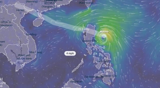
MANILA, Philippines — Severe Tropical Storm Paolo (international name Matmo) churned closer to the Philippines’ northern coast Thursday night, packing fierce winds and raising fears of destructive flooding as it barrels toward a likely landfall in the coming hours.
The Philippine Atmospheric, Geophysical and Astronomical Services Administration issued an urgent 11 p.m. bulletin warning that the storm — known internationally as Matmo — had strengthened into a severe tropical storm, with maximum sustained winds of 95 kilometers per hour (59 mph) near its center and gusts reaching 115 kph (71 mph). Last spotted east of Baler in Aurora province, the cyclone was accelerating westward at 30 kph (19 mph), setting the stage for a Friday morning strike.
Forecasters predict Paolo will slam into southern Isabela or northern Aurora provinces early Friday, carving a path across Northern Luzon’s rugged terrain before exiting the Philippine area of responsibility by Saturday morning. The storm’s rapid intensification has prompted widespread evacuations and school closures, with residents in vulnerable coastal communities bracing for what could be the season’s most disruptive blow.
Tropical Cyclone Wind Signal No. 3, signaling storm-force winds capable of uprooting trees and damaging structures, flies over swaths of extreme northern Aurora, central and southern Isabela, northern Quirino, northern Nueva Vizcaya, Mountain Province, Ifugao and northern Benguet. In these zones, gusts could topple power lines and isolate remote villages.
Lower warnings blanket broader areas: Signal No. 2, for gale-force winds, covers southern mainland Cagayan, the rest of Isabela and Quirino, much of Nueva Vizcaya and Aurora, northeastern Nueva Ecija, southern Apayao, Kalinga, Abra, most of Benguet, southern Ilocos Norte, all of Ilocos Sur and La Union. Signal No. 1, indicating strong winds that could still scatter debris, extends to the rest of Cagayan including the Babuyan Islands, remaining parts of Aurora and Quezon, Camarines Norte, northern Camarines Sur, Catanduanes, the rest of Apayao and Ilocos Norte, Pangasinan, most of Nueva Ecija, northern Bulacan, Tarlac, northeastern Pampanga and northern Zambales.
The most ominous threat looms from the sea: PAGASA cautioned of a moderate to high risk of storm surges, with waves cresting 1 to 3 meters (3 to 10 feet) along exposed coasts of Ilocos Norte, Ilocos Sur, Cagayan, Isabela, Aurora and Quezon over the next 36 hours. Low-lying fishing villages and beachfront settlements could face sudden inundation, echoing the deadly surges from past typhoons that have claimed hundreds of lives in this archipelago nation.
As Paolo closes in, emergency response teams are mobilizing sandbags, rescue boats and relief supplies, while the national government urges millions in its path to seek higher ground. The storm’s trajectory recalls the fury of recent cyclones that have battered the Philippines, a country lashed by about 20 such systems annually and perennially ranked among the world’s most storm-vulnerable.
Updates are expected hourly as Paolo’s eye sharpens its focus on the mainland.


