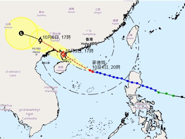
Typhoon Matmo churned closer to Hong Kong on Saturday night, prompting the city’s observatory to maintain its No. 3 strong wind signal into midday Sunday, though officials downplayed the odds of stronger gales battering the territory.
In a late-evening update at 9:45 p.m., the Hong Kong Observatory said the storm’s path would likely keep it more than 300 kilometers (186 miles) southwest of the city during its closest approach Sunday morning. That distance, the agency noted, makes a rare No. 8 signal — which signals hurricane-force winds capable of uprooting trees and halting transport — “unlikely” unless Matmo veers unexpectedly toward the Pearl River Estuary.
“The chance of sustained gale-force winds generally over Hong Kong is relatively low,” the observatory said in its assessment, easing some fears after earlier forecasts had raised eyebrows about the typhoon’s potential punch.
Still, the warning wasn’t entirely off the table. Matmo, packing maximum sustained winds of up to 120 kilometers per hour (75 mph), was expected to deliver intermittent squalls, thunderous downpours and fierce gusts that could whip up to 90 kph (56 mph) in exposed areas. Swells were forecast to roughen the seas, turning coastal waters into a hazardous churn.
“Members of the public are advised to stay away from the shoreline and not to engage in water sports,” the observatory cautioned, urging residents to batten down ahead of the storm’s brush-by.
The typhoon, which formed earlier in the week over the South China Sea, has already lashed southern China with heavy rains and disrupted shipping lanes. Hong Kong, a bustling hub of 7.5 million people wedged between mountains and the sea, has weathered dozens of typhoons over the years, but each one tests the city’s vaunted resilience — from skyscraper-sized ferries grounded at piers to school closures and flooded streets.
As of Saturday night, the No. 3 signal meant gusts up to 70 kph (43 mph), enough to rattle windows and complicate weekend plans but short of the chaos unleashed by higher alerts. Airlines reported no major delays yet, though ferry services to Macau and outlying islands were on standby.
Meteorologists tracked Matmo’s slow crawl northward, its eye wall churning moisture from the warm waters below. By Sunday afternoon, the storm was projected to weaken slightly as it nears the mainland coast, potentially dumping more rain on Guangdong province.
For now, Hong Kong hunkers under gray skies, a city on watch but not yet in full storm mode. The observatory promised another update by dawn, as Matmo’s whims could still shift the forecast in an instant.


