This report details a significant seismic event that occurred in the central Philippines, a region with high geological activity. The earthquake registered a preliminary magnitude of 6.9, prompting immediate public safety advisories and damage assessments by national authorities. The following summary table provides the essential high-level details of the incident based on initial reporting.
| Key Information | Details |
| Event Type | Strong Earthquake |
| Preliminary Magnitude | 6.9 (United States Geological Survey) |
| Date of Occurrence | Tuesday |
| Local Time of Occurrence | Approximately 10:00 p.m. |
| General Location | Central Philippines |
This initial overview establishes the fundamental parameters of the event. The subsequent sections provide a more granular analysis of the earthquake’s specific geological characteristics.

Detailed Seismic Characteristics
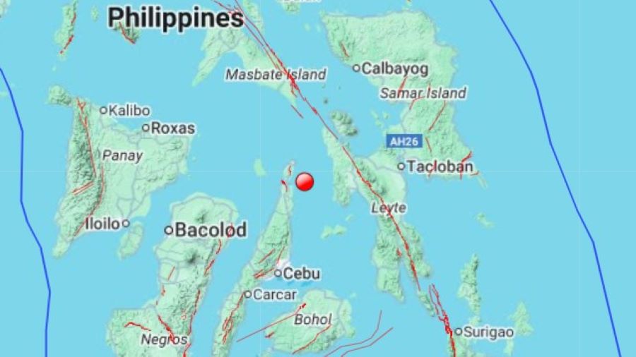
The earthquake’s shallow focal depth and underwater epicenter were the primary geological drivers of its felt intensity and the initial tsunami risk assessment. An analysis of these parameters clarifies the scope of the immediate public safety threat.
- Epicenter: The earthquake’s epicenter was located underwater, specifically situated “just west of Palampon in the eastern Visayas region.”
- Depth: The tremor originated from a shallow depth of approximately 11 kilometers. This characteristic was a key factor in “increasing the potential for noticeable shaking across nearby provinces.”
These seismic characteristics resulted in widely felt ground shaking, prompting immediate public reaction and damage assessments.
Initial Impact Assessment and Public Observations
In the immediate aftermath of the earthquake, response efforts prioritized the assessment of life safety and the structural integrity of critical infrastructure. The information gathered during this initial phase is preliminary, with more comprehensive evaluations pending.
- Casualties and Damage: Authorities reported “no immediate casualties or major damage” following the event.
- Ongoing Assessments: Authorities confirm that safety inspections are underway across Cebu and neighboring provinces to identify any potential structural compromise.
- Public Observations: The earthquake was widely felt, creating public alarm. In a notable example, “dramatic footage captured in Cebu City showed a beauty pageant halted as the building rattled from the quake.”
These initial findings on the ground-level impact informed the subsequent series of official directives and public safety advisories issued by national agencies.
Official Directives and Public Safety Advisories
In response to the seismic event, national and regional authorities issued a coordinated series of public safety directives focused on the primary secondary threats: potential tsunami effects and anticipated aftershocks.
- Tsunami Threat Assessment: The initial underwater nature of the quake prompted warnings of “possible localized tsunami effects.” However, this was later clarified by the Pacific Tsunami Warning Center, which confirmed “no major tsunami threat.” The local seismology office maintained a nuanced caution, advising of a “possible minor sea level disturbance.”
- Coastal Advisory: In response to the potential for sea level changes, residents of Leyte, Cebu, and Bileron were specifically urged to “stay away from the coast.”
- Aftershock Warning: Officials formally warned the public that “aftershocks are expected in the coming days.”
- General Public Guidance: The overarching directive for all residents in the affected regions was to “remain vigilant and follow official instructions.”
These immediate response measures are grounded in the broader geological context of the region, which is characterized by frequent and unpredictable seismic activity.
Geological Context and Status of Monitoring
This seismic event is consistent with the known geological profile of the region. The Philippines is highly susceptible to earthquakes due to its geographic position, a reality that presents inherent challenges for disaster prediction and preparedness.
- Regional Seismicity: The Philippines’ position on the “Pacific Ring of Fire,” a “belt of volcanoes prone to frequent seismic activity,” means that while most earthquakes are too weak to be felt, the potential for powerful, destructive quakes is a constant operational consideration.
- Earthquake Predictability: It is important to note that strong, destructive quakes “occur unpredictably.” There is “no technology currently available to forecast them,” underscoring the importance of vigilant monitoring and robust response protocols.
This incident remains a developing story. Authorities “continue to monitor the situation closely,” and further updates will follow as inspections and assessments continue in affected areas.
– HKPinoyTV Research Department | sources: Philvolcs, US Geologocal Survey