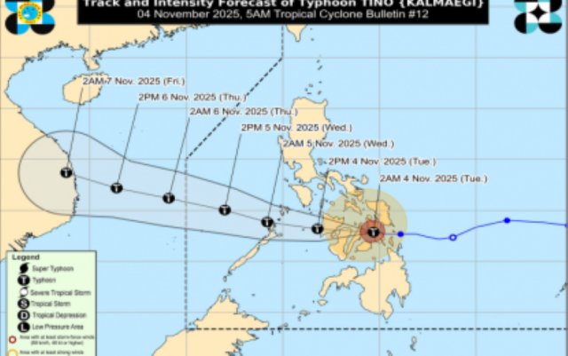
MANILA — Typhoon Tino (international name Kalmaegi) barreled across the central Philippines on Tuesday, slamming into Cebu province with winds of up to 150 kilometers per hour and triggering widespread storm warnings as it churned westward, the state weather agency said.
The storm made its second landfall at 5:10 a.m. in Borbon town on Cebu’s northern coast, weather specialist Chenel Dominguez told reporters in a 5:45 a.m. briefing. It was crossing the Negros Island Region and Western Visayas, with its eye over coastal waters off San Francisco, Cebu, packing gusts reaching 205 kph.
Tino first struck land at midnight in Silago, Southern Leyte, and was moving west at 25 kph, with typhoon-force winds extending 300 kilometers from the center.
The Philippine Atmospheric, Geophysical and Astronomical Services Administration hoisted Tropical Cyclone Wind Signal No. 4 — indicating winds of 118-184 kph within 12 hours — over western and southern Leyte; northern and central Cebu, including Camotes and Bantayan islands; northeastern Bohol; northernmost Negros Oriental; northern Negros Occidental; Guimaras; central and southern Iloilo; and southern Antique.
Signal No. 3 covered Southern Leyte, central and eastern Bohol, northern Negros Oriental, central Negros Occidental, the rest of Iloilo, southern Capiz and central Antique.
Signal No. 2 was raised across southern Masbate, southern Romblon, southern Oriental and Occidental Mindoro, and northern Palawan including the Calamian Islands, as well as central and southern Eastern Samar, central and southern Samar, the rest of Leyte, Biliran, the rest of Bohol and Cebu, central Negros Oriental, the rest of Negros Occidental, Siquijor, the rest of Capiz and Aklan, and the rest of Antique including Caluya Islands.
Signal No. 1 extended to Albay, Sorsogon, the rest of Masbate including Ticao and Burias islands, southern Quezon towns, southern Marinduque, the rest of Romblon and Mindoro provinces, central Palawan including Puerto Princesa City and Cagayancillo Islands; Northern Samar, the rest of Eastern Samar and Samar, and the rest of Negros Oriental; northern Surigao del Sur, northeastern Agusan del Sur, Agusan del Norte, Misamis Oriental, northern Bukidnon, northern Misamis Occidental and northern Zamboanga del Norte.
PAGASA warned of possible flash floods and landslides in Palawan, Western Visayas, the Negros Island Region and Central Visayas from heavy to torrential rains. Eastern Visayas, Northern Mindanao, Albay, Sorsogon, Masbate and the rest of the Mimaropa region faced gusty rains.
Cloudy skies with scattered rains and isolated thunderstorms were forecast for Metro Manila, Calabarzon, Central Luzon, Isabela and Aurora due to a shear line. The northeast monsoon was bringing cloudy skies and rain to Ilocos Region, Cordillera and the rest of Cagayan Valley.
Tino is expected to cross the Visayas and northern Palawan before emerging over the West Philippine Sea by Wednesday morning and exiting the Philippine Area of Responsibility by Wednesday evening or Thursday morning. It may weaken slightly over land but is forecast to remain a typhoon, PAGASA said.
Separately, a low-pressure area 2,165 kilometers east of northeastern Mindanao had a high chance of becoming a tropical depression within 24 hours, the agency reported.


